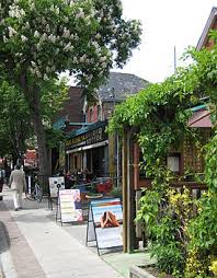
Baldwin Village hosts Pedestrian Sundays in the summer in association with the Kensington Market neighbourhood.
History
Baldwin Street was laid out and named after William Warren Baldwin, who owned much of the area, in the early nineteenth century.
William Warren Baldwin (April 25, 1775 – January 8, 1844) was a doctor, businessman, lawyer, judge, architect and reform politician in Upper Canada. He, and his son Robert Baldwin, are recognized for having introduced the concept of “responsible government“, the principle of cabinet rule on which Canadian democracy is based.
The Baldwin Village neighbourhood developed in the early 20th century as an offshoot of the Kensington Market Jewish community, and the strip became home to a number of Jewish stores and restaurants.
As the Jewish community moved north from downtown, the area’s proximity to Chinatown led it to be populated by Chinese-Canadians. Mandel’s Creamery at 29 Baldwin Street, the last remnant of the block’s Jewish heritage, closed in 1995 after 90 years of operation, though the Yiddish lettering on its window has been preserved by the cafe that took over the location.
Also close to the University of Toronto and surrounded by the area known as the “Student Ghetto,” Baldwin Village also became a centre for the 1960s youth movements. Most notably it was a central location for American draft dodgers from the Vietnam War. The draft dodgers converted a number of homes to shops catering to the new community. In 1978 the first cafe on the block opened, and since then the area has become one of the best known restaurant districts in Toronto.
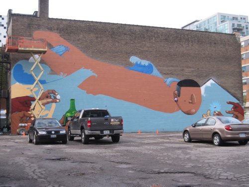
In the block of Toronto’s McCaul Street between Stephanie Street and Grange Road there are two splendid murals.
They are painted on the south-facing brick wall of 52 McCaul (previously home to Suzanne Greenaway’s Prime Gallery, and now home to the OCADU student gallery) and on the south-facing brick wall of the Brinks Building (latterly the Toronto headquarters of Otis Elevator, now leased by OCADU).
The 52 McCaul mural was painted in 2009 by the Brazilian artist Nunca under the auspices of the Manifesto Festival.
Founded in 2007, the Manifesto Festival of Community & Culture in Toronto is, in its own words, “one of Canada’s biggest celebrations of hip hop culture and beyond – a multi-disciplinary, world-class festival with a positive social and economic impact … empowering diverse communities of young people through arts and culture… building careers, fostering community connections and fuelling civic pride – all while contributing to the vitality of the city we love.”
Francisco Rodrigues da Silva (“Nunca”) is a Brazilian grafiteiro artist whose images confront modern urban Brazil with its native past. His tag-name Nunca (“Never” in Portuguese) echoes his determination not to be bound by cultural or psychological constraints.
Nunca has exhibited in Brazil at the Museum of Modern Art in São Paulo and around the world, notably in Greece at the AfroBrasil Museum and in the United Kingdom at the Tate Modern museum. The Tate Modern’s brick walls were decorated with six paintings 15 metres high by the artists featured in the exhibition, including Nunca. Here is some of his work in cities in addition to Toronto:
Nunca: The Tate Modern mural in London, 2008
Nunca: Boneyard Project for retired military planes, Tucson, 2011
Nunca: Frieght train, Sao Paulo, Brazil
Nunca: Gdansk, Poland, 2009
Nunca: Grotaglie, Italy, 2010
Nunca: Wynwood Walls, El Barrio, Miami
Nunca: The McCaul Street mural, Toronto
Just north of the Nunca mural on McCaul Street stands the Brinks Building. In 2014 a brilliant mural was painted there under the auspices of the artists’ collective ULTRA RARE.
ULTRA RARE was a “placemaking lab” surrounding 52 McCaul Street, on a site owned by Osmington, Inc. that will eventually be home to a new condominium and museum. (Founded in 1995 and headquartered in Toronto, Osmington, Inc., under CEO Lawrence Zucker, works with Canadian institutional investors to provide management, leasing, and development services for real estate properties.)
The Brinks Building mural was designed and painted by Julia Dickens, Tara Dorey, Alexandra Mackenzie, Lido Pimienta, Peter Rahul and Diana VanderMeulen. ULTRA RARE was supported by Osmington Inc., Prime Time Paints, and Vinci Park, and sponsored by Pittsburgh Paints (PPG) and Stephenson’s Rental Service Inc.
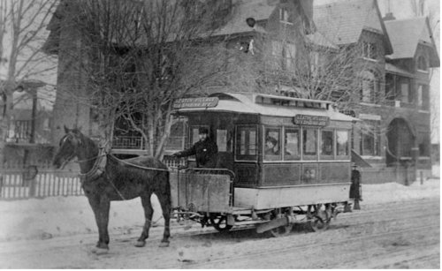
A ride on the northbound Spadina streetcar is a tour through history.
Pull the cord as you approach College Street and, if you listen carefully, you can hear the conductor cry out “whoa” as he tugs on the reins of the horse pulling the carriage.
The year is around 1890, and as you step off the streetcar you see a row of new two- and three-storey brick buildings on the east side of Spadina from College all the way down to Cecil Street. They have stores on the ground floor and apartments and businesses on the second and third floors. They will still be there 125 years later – a monument to Toronto’s immigrant history.
They should be preserved. They are not the monumental and justly famous historical buildings built in the same decade like the Beverley Street Baptist Church, the Gladstone Hotel on Queen West, the Bank of Montreal at Front and Yonge, or the James Cooper House on Sherbourne. However, the Spadina Avenue buildings are full of history and they help us understand how people came to Toronto from all over the world and became Canadians.
In fact Spadina Avenue (at left on the map below) is as important in the peopling of Canada as Pier 21 in Halifax, the Grosse Ȋle quarantine station in Quebec, or the seaport in Vancouver.
The word Spadina comes from the Anishinaabe word “Ishapadena” referring to a rise in the land or hill. The land belonged to the Anishinaabe-speaking Mississauga people, and the name means “those at the great river-mouth.”
A group of chiefs and elders met with representatives of the British government in 1787 to sell some of their land to the crown, a total of 250,808 acres (101,528 hectares), for around $9,500 plus 2000 gun flints, 24 brass kettles, 10 dozen mirrors, 2 dozen laced hats, a bale of flowered flannel, and 96 gallons of rum.
The chiefs signed with their pictographs, an eagle, a raven, a fish, etc. The British negotiators, for their part, didn’t do their job properly and revisions kept being made to the contract for the next 18 years. The Supreme Court of Canada two hundred years later decided it was still a bad deal and awarded the Mississaugas of the New Credit First Nation $145,000,000.
Despite the subsequent problems, Colonel John Graves Simcoe, lieutenant-governor of Upper Canada, “ordered his Executive Council to meet on September 2, 1793, at the new town site of York on Lake Ontario to distribute land to settle the area and keep the Americans out.”
The one hundred Park Lots were granted by Simcoe as douceurs to compensate his officials for uprooting themselves in Niagara and moving across the lake to York, an easier port to defend. They were required to develop the properties within a specified time. Park Lot 15, on which Spadina Avenue would eventually be built, extended from Queen Street up to Bloor Street. The lot was ten chains or 660 feet wide. William Willcocks was given Park Lot 15 and he also obtained a “farm lot” 1320 feet wide, north of Bloor to what is now St. Clair Avenue, on which Spadina would continue.
The Baldwin family, well-to-do Irish immigrants with six children, arrived in Canada in 1799 and stayed with the Willcocks family for a period of time. Eventually son Robert Baldwin http://www.biographi.ca/en/bio/baldwin_robert_8E.html , a doctor and a lawyer, married Eliza Willcocks – the great love of his life – and controlled land including lots l5 and 16.
He decided to follow the example of his friends and associates and in 1818 built a house up on Davenport Hill. (On that site a replacement home called Spadina House, pronounced Spa-deena , not Spadina with a long “i” like the Avenue, was built in 1866 by James Austin. Spadina House exists today as a museum, below.)
The house that Robert Baldwin built had a spectacular view toward Lake Ontario, and Baldwin began to imagine a grand boulevard, now Spadina Avenue, running south toward the lake. A normal road was one chain or 66 feet wide. Spadina Avenue would eventually be 160 feet wide.
Before that time there was a large field on the east side of Spadina that crossed what became College Street. It was called “The Common.” There is a wonderful watercolour painting of it, published in The Canadian Illustrated News (Hamilton) with the legendary Royal Regiment accepting Colours from the ladies of Toronto.
Mr. R. Towey, the current adjutant at the Fort York armoury, provided the following information. “Our regimental history Battle Royal describes the Common as “a large empty space west of Brock Street. The Presentation took place on July 6, 1863. A regiment’s Colours are ceremonial flags that are carried during parades and other ceremonies. There are traditionally two flags: the Queen’s Colour which is based on the national flag, and the Regimental Colour. Historically, their main purpose was to provide a rallying point for the unit on the battlefield. His Royal Highness Prince Charles presented new Colours to the Royal Regiment of Canada in November 2009.”
The heritage buildings we are concerned with today on the east side of Spadina were built on part of The Common. They begin at 439 Spadina Avenue south of College and run down to 381 Spadina Avenue at the corner of Cecil Street, the latter a three storey building with great mansards. It’s not entirely clear how many of the buildings in this block were constructed separately between 1880 and 1885; although there are 29 numbered addresses, somewhere between nine and thirteen individual structures were probably built that shared internal stairways and utilities.
Number 381 was sold on December 29, 1886, to I. Moncreeff for $5000. The grantor was S. Thompson and the property subsequently changed hands many times including to Hugh Crane, Ruth McRoberts, Josephine May Ross, then in 1926 to S. Zaritsky, followed by David Goodman, then Peter Lin in 1973. (Notice the international flavour of that series of names!)
Number 389 was guaranteed by S. Thompson to Anne Gordon in 1886 and was owned by many of the same names as number 381, including Ruth McRoberts, then Rose Greenberg in 1912. The Might’s city directory lists the kinds of stores in the ground floor starting in 1900 and including a stationary shop, a grocer, a ladies’ tailor, Imperial House Furnishing (representatives for Frigidaire refrigerators) and in 1934 John Garde & Company (now run in North York by the family’s fourth generation). Rosemary Donegan in her book Spadina Avenue writes “John Garde and Co. Ltd. was established in 1905 by John Garde (1861-1938), J.M. Statten and R.B. Mowbry, sewing machine adjusters-mechanics on Queen Street East. In 1921 they moved to 395 Spadina to service the growing garment industry of the district. In the mid-30’s they moved up the street, renovating the exterior of the shops.” The properties at 389 and 391 Spadina were sold by the Garde’s in 2002 to Son Dam.
Today the ARTarium Gallery (http://artarium.ca/about.html) occupies the ground floor of 389, with an eclectic and eccentric assortment of items of art for sale. The gallery belongs to a married couple Emily Suzuki and Sean Kulchar; originally her family was from Asia and his from Eastern Europe, a great example of Spadina’s history.
There is a laneway on the north side of 439 (left, above, with graffiti) that winds its way back to a collection of working class homes on Glasgow Street – many built to house Chinese families and their relatives who first came to Canada at the time the Canadian Pacific Railway we being built – and after a couple of houses the laneway heads back west behind the buildings on Spadina, turning south and coming out on Cecil Street, adjacent to the Cecil Community Centre.
“The building now known as Cecil Community Centre was built in 1890 by architects Knox & Elliott as the Church of Christ. By the 1920s, it was converted to a synagogue for the Ostrovtzer congregation, with substantial renovations, including demolition of the original church spire and the addition of marble tablets and a brass chandelier with a Star of David – features which remain to this day. By the 1950s, the congregation had moved and the building changed hands once again; over the next 20 years, it was variously a Chinese Catholic centre and the first home of the Community Homophile Association of Toronto before falling into disrepair. In the 1970s, the building was acquired by the City of Toronto and restored for community purposes. It opened as the Cecil Street Community Centre in March, 1978.” http://cecilcommunitycentre.ca/history
On the south side of Cecil, on the corner of Spadina, is Grossman’s Tavern (below), which opened in 1943 and describes itself as “one of the city’s longest-running live music venues, and Toronto’s self-described Home of the Blues.” Rock, folk, roots and jazz acts are also at home here, with Grossman’s motto “Never a Cover, Live Music.” A lot of would-be writers of books and music have downed substantial amounts of liquor at Grossman’s, searching for a muse.
A short distance south and a block to the east at 101 Huron Street is the First Baptist Church, the oldest continuing Baptist congregation in Canada, “founded (1826) by fugitive slaves who were drawn to Upper Canada by the promise of freedom. Like many that came to Canada, the founding members came with little more than their religious faith and their belief in the doctrine of the Promised Land … a paradise where they would find freedom from their earthly misery and bondage. And so it was that eight years before the abolition of slavery in the British Empire, 12 slaves from the Southern U.S made their way via the Underground Railroad to become the first members of First Baptist Church.” http://www.fbctoronto.ca/who-we-are/
Back on Cecil Street when you turn north at the intersection of Spadina Avenue you can see, on the opposite side of the street, the large palm tree neon sign of the El Mocambo club.
The El Mocambo had a no-frills reputation as a tavern with entertainment until one night in 1977 when the Rolling Stones showed up for an unadvertised concert and so did Margaret Trudeau (wife of the Prime Minister then and mother of the Prime Minister now), causing a sensation.
To this remarkably wide and diverse street immigrants came from all over the world. Many started their new lives on Spadina Avenue in the garment industry, in retail stores, in restaurants and in many other jobs including stripping at the Victoria Burlesque (below) at Spadina and Dundas. Men would line up at the door and when it opened race down to find a seat next to the stage.
Many immigrants had suffered terribly under brutal dictatorships, others from religious persecution, wars, depressions and abject poverty. When they arrived in Toronto they had to get along with people they considered enemies back home. Spadina was definitely a tough street, a battleground of competing ideologies from Fascism to communism and orthodox to reform religions, racism and many other “isms,” but Spadina represented hope especially for future generations. As each wave of immigrants did better they moved on up or out and across the country and built Canada.
Their heritage – our heritage – on Spadina is disappearing. Property developers, often with little or no regard for heritage, are constructing large, impersonal – and profitable – buildings around College and Spadina. If these new projects fail to respect and embrace the heritage buildings, all that will be left is a brass plaque stating that once upon a time this was a vibrant neighbourhood – that has vanished.
The Spadina heritage project needs lots of help. The following are questions that I have not found the answers to. If you have any corrections or new information, please contact me at dennismcintosh@outlook.com
Were the Baldwins themselves initially responsible for developing the properties south of College?
Does anyone know the name of the architects and landowners who devised the first buildings?
How would the original buildings be described architecturally?
Does anyone have any historical information about other owners or tenants?
And … we need creative ideas of how to preserve the buildings while incorporating them into future development.
Sources for this article are many and include: The Toronto City Archives; The Toronto Public Library; Rosemary Donegan’s Spadina Avenue; Wendy Smith’s unique web site: http://wendysmithtoronto.com/parklotproject/; Nathan Ng’s blog: http://oldtorontomaps.blogspot.ca/ ; Austin Seton Thompson’s Spadina, A Story of Old Toronto; Allan Levine’s Toronto, Biography of a City; and Edith Firth’s The Town of York, 1793- 1815.
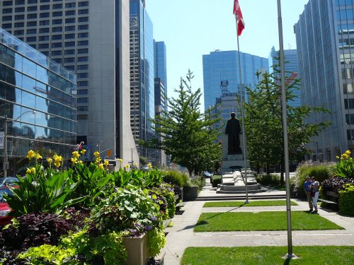
University Avenue defines the eastern edge of the Grange community. It is an eight-lane boulevard, landscaped along its centre, that runs from the Ontario Parliament buildings in Queen’s Park south nearly to the waterfront.
University Avenue began life in 1829 as College Avenue, a private road leading to King’s College which was the ancestor of the University of Toronto, standing where Queen’s Park is today. College Avenue was closed to commercial traffic and no streets were allowed to intersect it. Access was controlled by gatekeepers at both ends of the Avenue.
The City, stalled in its expansion by this private enclave, obtained a 999 year lease on the Avenue in 1859 and opened it to general traffic. Running parallel to College Avenue was Park Lane, later called University Street, which was eventually absorbed by a widened University Avenue.
The Adam Beck Memorial, south of the intersection of University Avenue and Queen Street, honours Sir Adam Beck (1857-1925), the founder of Ontario Hydro, the provincial electricity provider. The statue was commissioned in August 1929 and was designed by Emanuel Hahn. Unveiled in September 1934, its inscription reads: “Erected by the Corporation of the City of Toronto and the Toronto Hydro Electric Commission in grateful commemoration of the public services of Sir Adam Beck, KT. LLD. MLA., whose labours have ensured that the citizens of his native province under co-operative municipal ownership shall enjoy the benefits of low cost electrical energy derived from water power resources to serve the industrial and domestic needs of the Province of Ontario. Nippigon, Trent, Eugenia, Severn, Muskoka, Rideau, Nipissing, Niagara, Queenston-Chippawa.”
Beck was an early and prominent advocate of publicly owned electricity grids, opposing the privately owned companies that he felt did not adequately serve the needs of the public. With the slogan “Power at Cost” and in Latin, “dona naturae pro populo sunt” (“the gifts of nature are for the public”), he convinced Premier Whitney to create a board of enquiry on the matter, with him as chair. The enquiry suggested creating a municipally-owned hydroelectric system, funded by the provincial government, and using water from Niagara Falls and other Ontario lakes and rivers. In 1906 Whitney appointed Beck the first chairman of the Hydro Electric Power Commission of Ontario. He was knighted by King George V in 1914 for his promotion of electricity and development of transmission lines.
In 1902, Adam Beck was elected mayor of London, Ontario, and a few months later was elected to the Ontario legislature as the Conservative member from the London riding. Already a wealthy man, he donated his salary to charity while serving as mayor. His daughter Marion, born in 1904, suffered from tuberculosis, but due to Beck’s wealth and influence she had access to the best doctors and medicine. Realizing that not everyone could afford such care, in 1910 Beck founded the Queen Alexandra Sanitorium which was very advanced for its time.
In 1915, he tried to introduce a network of interurban railways (long-distance trolleys) in Ontario under public ownership, but this plan was put on hold during World War I. Beck continued to push his railway proposal after the war, which pitted him against Premier Ernest Drury, with whom he had an antagonistic relationship. In 1920, Drury created a Royal Commission which concluded that the popularity of automobiles had rendered Beck’s public transit proposal obsolete.
South African War Memorial
James Mason (1843-1918) was a Canadian banker, senator and military officer. He was born in Toronto and educated at private schools and the Toronto Model School where he was head boy. After graduation, he joined the Toronto Savings Bank which ultimately became the Home Bank. He became its general manager and president in 1873. The bank collapsed in 1923 (the next collapse in the extremely stable Canadian banking system did not occur until 1985).
Mason was appointed to the Canadian Senate in 1913 by Prime Minister Robert Borden and sat as a Conservative. He was one of the founders and funders of the Toronto Mechanics’ Institute which ultimately evolved into the Toronto Public Library. Mason was a founder of the Royal Canadian Military Institute on University Avenue and served as its president. He was also an ardent imperialist and a founder of the Empire Club of Canada.
Campbell House
Campbell House, now on the northwest corner of University Avenue and Queen Street, is the oldest remaining house from the original site of the Town of York. It was built in 1822 by Upper Canada Chief Justice Sir William Campbell and his wife Hannah.
The house was originally located on a plot of land 1.5 kilometres to the east of the intersection of what is now Adelaide Street (formerly Duke Street) and Frederick Street. For most of the 19th century the house was a private residence. By 1890 the neighbourhood had changed into a commercial and industrial zone. The building eventually came to be used as office space and a factory, including a horseshoe nails company and an elevator company.
In 1972 the last owners of the property, the Coutts-Hallmark Greeting Cards Company, wanted to demolish the house in order to extend their parking lot. Prior to demolition the house was offered to anyone who could remove it from the property. A professional association of trial lawyers known as the Advocates Society, launched a campaign to save the building. With assistance from Toronto Transit Commission maintenance trucks, the 270 -tonne home was moved 1617 metres northwest from Adelaide Street to the current location.
The six-and-a-half-hour move was a major spectacle, and attracted a large crowd as several downtown streets needed to be shut down. Fully restored, it was reopened by Her Majesty Queen Elizabeth, the Queen Mother, in April 1972.
The preservation of the house was an important turning point in architectural preservation in Toronto. During the 1950s and 1960s, 19th century homes were demolished at a rapid rate, and architect Eric Arthur even predicted that by the year 2000 there might be no 19th century buildings left in the city. The spectacle of the physical move to save Campbell House was a preservation achievement which sparked greater interest among Torontonians to save other local landmarks.
The Canada Life Assurance Company agreed to lease the house’s current location to the city of Toronto for one dollar a year in exchange for the city forgiving the property taxes on the lot.
The Canada Life Assurance Company
The headquarters of the Canada Life Assurance Company, on the west side of University Avenue north of Queen Street, opened in 1931 (the photo shows the building under construction in the summer of 1930, with the British airship R100 overhead). At the time Canada Life was the largest insurance company in the country.
The Beaux Arts style building was designed by architects Henry Sproatt and Ernest Rolph. It remains one of the largest office buildings in Toronto that has windows that can be opened.
Four Seasons Centre for the Performing Arts
The Four Seasons Centre for the Performing Arts, on the southeast corner of University Avenue and Queen Street, seats 2071 in five tiers. All interior and exterior noise has been reduced to the threshold of hearing – for the average listener, the room is perfectly quiet. The result is one of the quietest opera houses in the world.
The main façade has an exterior shade, computer controlled and linked to weather sensors, which can reduce heat gain in the lobby which is named the Isadore and Rosalie Sharp City Room. During the day a system of exterior roller shades with sun-tracking controllers raise and lower to protect the building against thermal gain and glare as the sun travels around the building. When not in use, the shades can retract completely.
The three-storey glass staircase rising through the lobby is the longest free-spanning glass staircase in the world – a glass staircase of this magnitude had never been attempted before.
Full rear and side stages allow three productions to be simultaneously playing in repertory. The fly tower is 33.9 metres high from the stage to the grid – equivalent to an 11-storey building.
In 1984 Ontario premier Bill Davis promised that provincially owned land on the southeast corner of Bay and Wellesley Streets would be the home for a new opera house. A design competition was won by the architect Moshe Safdie. In 1988 the project was approved and the existing stores and government offices on the site were demolished.
In 1990 a new NDP provincial government was elected which found the $311 million project excessively costly. The province was also still dealing with the $550 million cost of the SkyDome project that had become a financial disaster for the government. Thus two months after being elected the new government withdrew its funding for the project, and the land was sold to developers.
In 1997 the province said a parking lot that had previously been the site of offices for the Supreme Court of Ontario at Queen Street and University Avenue would be made available for the project. The lot was valued at C$31 million and the federal and provincial governments also pledged funding for a new, more modest project that would only cost some $130 million. The original plan called for a 190 metre tower of offices and condominiums to be built by Cadillac Fairview that would help fund the project. It would be further supplemented by a $20 million donation by Christopher Ondaatje. However both Cadillac-Fairview and Ondaatje developed concerns about the project and pulled out, and the city government under mayor Mel Lastman refused to provide any municipal funding. The project collapsed again in 2000.
In 2002 the Canadian Opera Company launched a new set of plans that included a $20 million donation from the Four Seasons hotel chain in exchange for perpetual naming rights to the complex. The complex took three years to construct at an estimated cost of $181 million, and is home to the Canadian Opera Company and the National Ballet of Canada. Elevator access to the concourse level of Osgoode subway station was integrated into the construction of the Centre which, along with an elevator to the platform level within the fare-paid area, makes the station fully accessible.
Royal Canadian Military Institute and Residences
The origin of the Royal Canadian Military Institute goes back to the year 1890 when Lt. Colonel William Otter – who earned fame and promotion in the South African war, retiring as a General with a knighthood – encouraged others to help him create an institute where members of Canada’s fledgling military units could, through in-house discussions and talks by well informed guest speakers, be kept up-to-date on the modern tactics and strategy of war.
It wasn’t until 1907 that a permanent home for the Institute was purchased for $7,000. The house was located at 245 Simcoe St. It had a backyard that stretched to the east and opened out onto the College Avenue (now University Avenue).
As the organization grew in both stature and members, the Simcoe Street house was remodeled and enlarged with the purchase of the neighbouring house to the south. In the process the backs of these two houses were extensively altered so they became the front, giving the Institute its 426 University Avenue address. Just across and down the street was the fortress-like University Avenue Armouries where many of Toronto’s militia units met and drilled. The Institute’s location was perfect. In 1946 the distinguished prefix “Royal” was granted by King George VI.
The building had been expanded in 1935 and renovated in the 1960s, but by 2008 the RCMI was fast approaching a critical crossroad. With club membership hovering around 1500, the RCMI was operating in the black, but only by a narrow margin. Its building remained stately, but it was in need of millions of dollars’ worth of reconstruction – millions of dollars that the RCMI did not have. The refitting that was required was neither cosmetic, nor optional: the RCMI was riddled with termites.
Desperate times call for desperate measures, and two long-time RCMI members hatched a bold plan to “destroy the Institute, in order to save the Institute.” Honourary Colonels Peter Hunter and Jeff Dorfman proposed selling the property to a developer in order to construct a major condominium tower. (Hunter died in 2009 shortly after he got the ball rolling on this project, and Dorfman never got to see the final product as he died in 2014.) The mansion sat atop prime real estate in Toronto’s downtown core and as a result RCMI could demand fair value in return. Tribute was the selected developer and the premise was to tear down the existing, deteriorated building (below), dig a solid foundation and erect a 42-storey skyscraper.
The RCMI was given the lower six floors in the new tower in freehold, and it was agreed that a likeness of the original façade would be included in “The Residences at the RCMI.”
On the 6th floor there are nine rooms and suites, and all of them would be equal to the best 5-star hotels. (The old mansion had a total of six rooms available to members, but these were primitive small nooks, with single beds and antiquated washbasins.) The fifth floor contains a fitness centre with a wide array of equipment and a view out onto University Avenue. Below the gym is the RCMI’s pièce de résistance – its world-renowned library.
On the third floor is the long bar, complete with the cockpit seat taken from the Red Baron’s downed Fokker triplane, the short bar, and the main dining room. The second floor contains meeting rooms, the administrative offices and a lounge replete with military miniatures in display cases. The ground floor entrance foyer on University Avenue, open to the public, includes an informative display of Canadian military miniatures, hats and helmets, and a photographic history of the building.
Demolition and excavation began in 2010, the cornerstone was laid in 2012, and the new building opened in June 2014. The historic facade, and much of the interior, was recreated. On the exterior of the building, Zeidler Partnership Architects used multiple finishes: non-reflective glazing framed by charcoal gray mullions in contrast with vertical white spandrel and aluminum accents. The north and south elevations include dark gray granite paneling at their bases. The north elevation, built close to the Air Miles office tower at 438 University Avenue, has no windows. Zeidler avoided the curse of a blank wall by cladding this elevation in spandrel panels of black, white and various grays in a mammoth grayscale scatter.
When the history of automobile traffic in Toronto is written, the RCMI building will hold a prominent place. Unlike every other modern condominium previously built in Toronto, the RCMI – with its 318 condos – has no private car parking facilities. There are nine underground spaces for rental “auto-share” cars, but no other parking spaces, in contravention of city building regulations. Those regulations, requiring hundreds of parking spaces for a building this size, were written when the car was king, before downtown density had increased along with traffic congestion, and before taking public transit or walking to work , shopping, or entertainment had become fashionable. The RCMI building was an experiment: would people buy condominiums that had no place to park, especially if the building was well served by subway and streetcar lines? The answer was yes; the majority of units were sold in advance, even before a sales office was opened. The parking space variance obtained by the RCMI, through the intervention of city councillor Adam Vaughan, has since served as a model for most other downtown condominiums and apartments, which are being approved with much reduced parking requirements. The RCMI, incidentally, includes 319 bicycle parking spaces.
Text based on the RCMI official history, the UrbanToronto website, Wikipedia, Mike Filey in the Toronto Sun, and Scott Taylor in the magazine Esprit de Corps.
Osgoode Hall
Osgoode Hall, on the northeast corner of University Avenue and Queen Street, was constructed between 1829 and 1832 in the late Georgian Palladian and Neoclassical styles after a design by architects John Ewart and W. W. Baldwin. It now houses the Ontario Court of Appeal, the Divisional Court of the Superior Court of Justice, and the Law Society of Upper Canada.
The portico of Osgoode Hall’s east wing was built at the head of Toronto’s York Street to serve as a terminating vista, though it is now obscured by trees planted on the building’s lawn. The building has been expanded, restored and renovated ten times.
Osgoode Hall was named in honour of the province’s first chief justice, William Osgoode. The law school was established by The Law Society of Upper Canada in 1889 and was the only accredited law school in Ontario until 1957. The building housed Osgoode Hall Law School until 1969 when the faculty was relocated to the campus of York University
At the time it was built, everything about Osgoode Hall made it stand out: the scale of the building and the property in a district of single-family homes, its business and public purpose in a residential neighbourhood, its professional occupants in a working class area, and its wealth in “The Ward,” the city`s main reception area for new immigrants and once one of the city’s worst slums. Today Osgoode Hall is surrounded by skyscrapers and pavement.
The six-acre site at the corner of Lot Street (Queen Street West today) and College Avenue (University Avenue today) was acquired by the Law Society of Upper Canada in 1828. At the time, the location was on the northwest edge of the city.
Osgoode Hall has had to share its six acres with other structures over the years. The grounds have been occupied by wood and coal sheds, a carriage house, a stable, a boiler house and lavatories. In 1886, the west lawn was turned into tennis courts for law students. More recently, plans for an eleven-storey tower on the west lawn and for an underground library under the front lawn have been considered and abandoned.
At the edge of the property along Queen Street and north along University Avenue, there is an ornate iron fence completed in 1867. It is renowned for its peculiar “cow gates.” While tradition is that they were installed to keep out wandering cattle (Osgoode Hall was originally in the country) it is more likely that the gates were a Victorian whimsy.
In 1861 the highly publicized case of John Anderson was heard in the courtroom at Osgoode Hall. The Anderson case established a clear precedent against allowing refugee extradition back to the United States, thereby protecting Underground Railroad refugees from being returned as fugitive slaves.
The Grange community is a Neighbourhood with a commercial/residential or Mixed Use area around the edges. These are terms defined in Toronto’s Official Plan, enforced by zoning by-laws that allow certain kinds of buildings and uses in certain places, and forbid others.
A Neighbourhood according to the Official Plan consists of residences and may include apartment/condo buildings of no more than four storeys. A mixed use or commercial-residential area has buildings that are frequently tall with stores, offices and residences mixed together in one building.
SPADINA AVENUE
Spadina Avenue defines the western edge of the Grange Community. It is a wide, mixed use avenue that runs between Bloor Street in the north and the Gardiner Expressway at the Lake Ontario waterfront, with a dedicated streetcar right-of-way and passenger shelters along its median.
Spadina was built beginning in 1815 from Bloor to Queen by Dr. William Baldwin. Baldwin chose its extra large width (160 feet!) and positioned the circle that is today 1 Spadina Crescent. He named the connecting Baldwin Street after himself, and Phoebe Street to the south was named after his wife Phoebe Baldwin.William Baldwin (1775-1844) was a doctor, businessman, lawyer, judge, architect and reform politician in Upper Canada. He and his son Robert Baldwin are recognized for having introduced the concept of responsible government, the principle of cabinet rule on which Canadian democracy is based.
Spadina Avenue, 1906 (City of Toronto Archives)
The south end of Spadina looking toward Lake Ontario, 1927 (City of Toronto Archives)
For a number of decades, Spadina Avenue and nearby Kensington Market were the centre of Jewish life in Toronto with the area around Spadina being the home of the garment district – where many Jews worked – as well as numerous Jewish delicatessens, tailors, bookstores, cinemas, Yiddish theatres, synagogues and other political, social and cultural institutions. In the 1950s and 1960s, the Jewish community moved north along Bathurst Street, but signs of Spadina’s Jewish history can still be found in many locations.
In the mid 20th century, Toronto’s Chinatown moved west along Dundas into the Spadina area. (A Toronto Chinatown first appeared during the 1890s with the migration of American Chinese from California due to racial conflict and from the Eastern United States due to the economic depression at the time.) Toronto’s so-called First Chinatown was centred near present-day Elizabeth and Hagerman Streets. Situated in what was then known as The Ward, the city’s largest slum area for incoming immigrants, the area was expropriated in 1955 to make way for Toronto New City Hall and Nathan Philips Square. More than three-quarters of the neighbourhood was commandeered as a result of the forced dispossession, and the Chinese businesses were forced to move.
The present downtown Chinatown is centred at Spadina Avenue and Dundas Street. Although a small Chinese community was already present here prior to the 1950s, the commercial area was formed mainly when businesses moved from the First Chinatown to the Spadina location.
Toronto’s downtown Chinatown is one of the largest in North America. It reflects a diverse set of Asian cultures through its shops and restaurants, including Chinese, Vietnamese and Thai. While the majority of the grocery stores and shops remain, most of the once-famed restaurants on Dundas Street West have closed since 2000. Unlike the newer developments in the suburbs, today’s downtown Chinatown relies heavily on tourism and Chinese seniors. As many younger, higher-income immigrants have settled elsewhere in the suburbs which now have their own Chinatowns, those left in the district are typically from older generations who depend on downtown’s dense concentration of services and accessibility to public transportation.
College Street defines the northern edge of the Grange Community. Across College, all the way from Spadina to University, our community adjoins the campus of the University of Toronto.
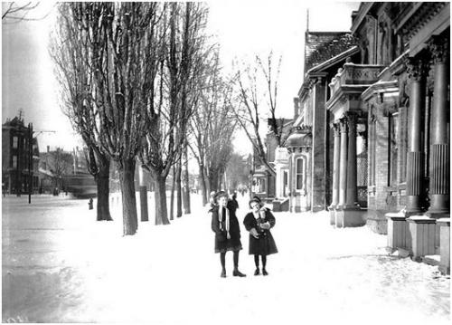
College Street in the 1890s (City of Toronto Archives)
Named after King’s College, now the University of Toronto, College Street marks the southern boundary of the original 1827 land grant for the college. The street was proposed as an east-west route along the boundary, although our section was not built until 1859. The first section built was to the west of Spadina Avenue, through the estate of Robert Baldwin, who laid out the route. This section was built with a 100-foot (30 m) width.
Drinking fountain for people and horses at College and Spadina, 1899 (City of Toronto Archives)
Between University and Spadina Avenue, College Street marks the beginning of our Grange Community to the south.
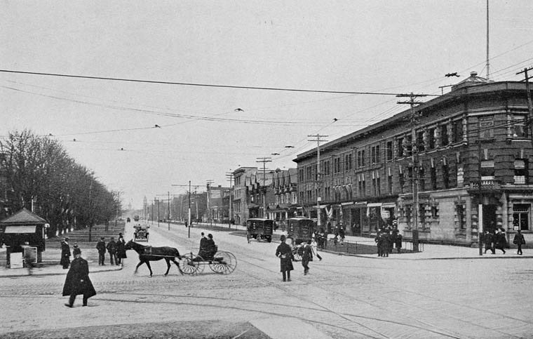
College and Spadina, 1909, looking east toward the Methodist Broadway Tabernacle Church, designed in 1897 by E. J. Lennox (City of Toronto Archives)
College and Spadina, 1927, looking east (City of Toronto Archives)
College Street and McCaul Street with streetcar track diversion, looking east. The University lands are to the left. 1930 (City of Toronto Archives)
College and Beverley Streets, 1937 (City of Toronto Archives)
QUEEN STREET WEST
Queen Street defines the southern edge of the Grange Community. Queen Street was the cartographical baseline for the original east-west avenues of Toronto’s grid pattern of major streets. Over the past twenty-five years, Queen West has become an international arts centre, and a major tourist attraction in Toronto.
Since the original survey in 1793 commissioned by Lieutenant Governor John Graves Simcoe, Queen Street has had several names. For its first sixty years, many sections were referred to as Lot Street. In 1837 Lot Street was renamed in honour of Queen Victoria.
Looking north up Spadina Avenue from Queen Street, 1909. Library and Archives of Canada C000283
The area of Queen Street between University and Spadina Avenues was a cultural nexus in the 1980s known for its cheap restaurants, clubs, eclectic mix of musicians and artists and was a haven for the punk rock scene. The late 1980s saw the relocation of CityTV to 299 Queen Street West which gentrified the area almost overnight. A more mainstream culture soon attracted wider audiences and wealthier businesses to the area. Small independent businesses started to move further west on Queen Street West past Spadina Avenue and Bathurst Street for the cheaper rent. While some original businesses have remained, the strip is now home to upscale chain stores, pricey restaurants and fast food outlets.
The broadcast hub at 299 Queen Street West at the corner of John Street – formerly the home of MuchMusic and, before that, Ryerson Press – now houses a number of Bell Media operations in a neo-Gothic heritage building faced with terra cotta. The building (below) was designed by Burke, Horwood and White in 1913 as the headquarters of the Methodist Church of Canada.
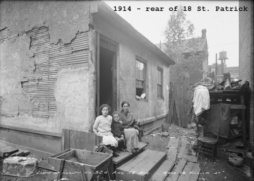
Photographs from the City of Toronto Archives. Anderson Street (as it was then) is Dundas Street now. William Street (as it was then) is St. Patrick Street now
48-50 McCaul Street built against the south wall of 52 McCaul. The house on the left (50 McCaul) left a ghost image of its structure on the adjacent wall.
The south wall of 52 McCaul Street shows a ghost image of the 50 McCaul house that was formerly built against it.
In 2009 a mural by the Brazilian artist Nunca was painted on this wall. In its early stages it looked like this:


![s0372_ss0079_it0200[1]](http://www.grangecommunity.ca/sites/default/files/images/spadina2.jpg)


